
Milwaukee County Park System
R/C Model Airplane Field
7000 W. Oakwood Rd.
Franklin, WI 53132
The Milwaukee County R/C Model Airplane Field is conveniently located in an urban county. The field is in 1,000 acres of Root River floodplain owned by the county, thereby offering a large flying area and resistance to urban development. The field is operated and maintained by RAMS for the public benefit.
A field license is required to fly at the field. A visitor may fly on one occasion as the guest of a current field license holder, if the visitor is an AMA member.
The field is an FAA-Recognized Identification Area (FRIA). This means you can fly at the field without Remote ID equipment. The FAA altitude limit for the field is 700ft above ground level.
The field offers pit tables shaded by canopies, engine starting tables, and pilot flying stations following AMA safety guidelines. The pit and flying areas are separated from spectators by fencing. A warming shelter is available for flying in the winter. 12 and 24VDC power is available for charging batteries.
The Root River is east of the field and Ryan Creek is on the north edge of the field. The field sometimes floods during the spring snow melt and after very heavy rains. The flooding usually lasts for only a few days at a time. This very flooding discourages other uses from displacing the field.
- When the Root River level reaches about 6 feet, Ryan Creek overflows its banks onto the field and the Root River backs up onto the field. This causes flooding in the east, north, and west low-lying parts of the field.
- When the Root River level is about 7 feet or more, the entire field floods and Oakwood Road floods at the nearby river crossing. This causes the city of Franklin to close Oakwood Road, making the field inaccessible by vehicle.
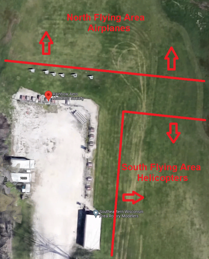
The field is divided into a North flying area for airplanes and a South flying area for helicopters as shown below. See the field rules for further information about flying in these areas.